1948 | 1980 | 1998
Lhasa Archive Map Page

Based on "Lasashi Qutu" (Xian 1991), the City Development Atlas (Lhasa, 1981) an offical survey by Peter Aufschnaiter (1947/48) and research by LAP. Drawn in MiniCAD 5.0 by Andre Alexander and Moritz Wermelskirch, Berlin 1994-97 copyright Lhasa Archive Project.
Part I - 1948
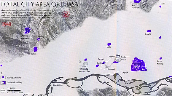
The Tibetan Holy City of Lhasa was founded in the 7th century. Lhasa means "Place of the Gods." The Jokhang Temple is the oldest existing building, first constructed in around 641 AD. This series of maps illustrates the growth of the total city area of Lhasa from 1948 until 1998. It also shows the fate of the traditional old buildings recorded in 1948 over the subsequent fifty year period.
In 1948, the city of Lhasa is defined by the Lingkor (marked in white). This is a circular road for the religious purpose of circumambulation. The Jokhang temple lies at the heart of the city proper, with the Potala Palace and the medical college at the Chakpori Hill to the west. Other important sites in the Lhasa valley are the Summer palace of the Dalai Lama, the monasteries of Sera and Drepung, and the seat of the Tibetan state oracle at Nechung. The other small settlements scattered throughout the valley are farming villages and noble estates. Not shown here are the various parks and individual summer houses of the aristocracy. Trapchi is the site of the government mint, with an ancient monastery nearby.
1948 | 1980 | 1998
Lhasa Archive Map Page