Asian Arts | Associations | Lhasa Archive Main | Contact Tibet Heritage Fund
Map of the 76 houses

Lhasa Archive Project
Lhasa Map
The Lhasa Archive Project has resently produced a multi part map of the historic changes which have occurred in Lhasa from 1948 to the present day. The Map consists of three parts:
- A series of three maps showing the state of the entire urban area of Lhasa in 1948, 1980 and 1998. These are reproduced below.
- A series of three map showing highlighting the number of pre-1948 buildings existing in the old city of Lhasa in 1948, 1985 and 1998.
- A map showing The Lhasa Historic City Conservation Plan, showing 25 historic building earmkarked for preservation by cultural and administrative departments working in conjunction with The Tibet Heritage Fund, LAP and The Norway-Tibet Network for University Cooperation.
In regard to the second series of maps, showing pre-1948 buildings, it should be noted that some of the new construction in the inner city has what is officially known as "Tibetan characteristics". The facades of these buildings, with varying success, have some Tibetan elements. This kind of building however is not part of the survey presented here. Only buildings built in the traditional, pre-industrial Tibetan style are included. The two types of buildings (authentic old and modern Tibetan style) can be easily distinguished upon closer scrutiny (and of course also with the help of our map). We do not wish to make any judgement of the modern Tibetan-style buildings. Indeed, it could be wished more buildings with Tibetan characteristics would come up in the other parts of Lhasa. But the main purpose of our research has been the identification of historic buildings. With this basic inventory completed, we can now proceed with trying to protect the last old houses.
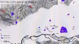
The images below show small versions of the first series of maps, where the total urban area of the Lhasa valley is hown in blue in 1948, 1980 and 1998. This clearly shows the extraordinary growth which has taken place over the past 50 years.
Click on the small images to go to larger images with full captions.
1948: urban areas in blue
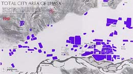
1980: urban areas in blue
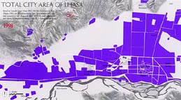
1998: urban areas in blue
Top
Map of the 76 houses
Asian Arts | Associations | Lhasa Archive Main | Contact Tibet Heritage Fund